| Published July 17, 2025
🇵🇭 What’s happening now: Tropical Storm Crising (Wipha)
🔍 Storm Overview
-
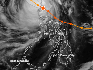
Named “Crising” by PAGASA (international name Wipha), this system has intensified into a tropical storm and is currently over the coastal waters near extreme northern Luzon
-
As of 3 AM PHT on July 19, 2025, Crising was located about 110 km WNW of Calayan, Cagayan, moving west‑northwest at 25 km/h, with sustained winds of 85 km/h and gusts up to 115 km/h
🌧️ Rain & Flooding
-
The storm is enhancing the southwest monsoon (habagat), leading to widespread heavy to torrential rain across large swathes of Luzon — Metro Manila, Central Luzon, Northern Luzon — as well as parts of Visayas and Mindanao
-
Batanes, Cagayan, and parts of Ilocos Norte, Apayao, Isabela are under Tropical Cyclone Wind Signal No. 2, signaling gale-force winds
-
Y and O rainfall warnings are active in urban and low‑lying regions — Metro Manila, Bulacan, Pampanga, Rizal, Cavite, Batangas, along with flood-prone provinces like Zambales and Bataan
🌊 Coastal & Marine Conditions
-
Sea travel suspended across North Luzon ports. Waves in the Luzon Strait range from 4.5 m to 6 m The Watchers.
-
A storm surge warning indicates a minimal to moderate ~1–2 m rise in waves for exposed coastal areas—especially Cagayan, Babuyan Islands, Batanes, Ilocos Norte/Shorelines PAGASA.
🌏 Geography: Why the Philippines is Prone to Typhoons
The Philippines is one of the most disaster-prone countries in the world, and its geography is a major reason why typhoons strike so frequently. Here’s a deeper look:
📍 Strategic Location in the Pacific
-
The Philippines is situated in the western Pacific Ocean, just above the equator, between 5° and 20° north latitude and 115° to 130° east longitude.
-
It lies along the northwestern edge of the Pacific typhoon belt, a zone where tropical cyclones commonly form due to warm ocean waters and atmospheric conditions.
-
The country sits within the Pacific Ring of Fire and directly along the “main highway” of West Pacific tropical storms, which move westward from the open Pacific, often strengthening as they approach land.
🌀 Typhoon Alley
-
On average, 20 tropical cyclones enter the Philippine Area of Responsibility (PAR) every year, with 8 to 9 making landfall.
-
These storms typically originate from the intertropical convergence zone (ITCZ) and tropical depressions east of the Philippines.
-
The Philippines is the first major landmass these storms hit, often bearing the brunt of their impact before the systems move on toward Vietnam, China, or Taiwan.
🧭 Archipelagic Structure
-
The Philippines consists of over 7,600 islands, meaning there’s always exposed land in the path of typhoons, especially in the eastern seaboard (Samar, Leyte, Bicol, Aurora, and Quezon).
-
With a vast coastline of over 36,000 kilometers, many communities are vulnerable to storm surges, coastal flooding, and strong winds.
-
The archipelago’s mountain ranges (like the Sierra Madre) can either weaken storms or, in some cases, create orographic rainfall, increasing the risk of landslides and flash floods in mountainous areas.
🌊 Warm Ocean Waters
-
The surrounding Philippine Sea and Pacific Ocean maintain sea surface temperatures above 26.5°C (79.7°F)—a critical ingredient for typhoon formation and intensification.
-
Warm waters act like fuel, allowing storms to grow stronger quickly before they make landfall.
🧭 Geography Amplifies Risk
-
Metro Manila, home to over 13 million people, sits on a low-lying delta, making it vulnerable to both inland flooding and storm surges.
-
Eastern provinces like Samar, Catanduanes, and Bicol often serve as the first impact zones—and many are rural, mountainous, and economically disadvantaged, making recovery more difficult.
As of the latest official updates, there have been no reported casualties in the Philippines due to Tropical Storm Crising (Wipha).
-
The NDRRMC has released data indicating that 7,501 families (23,918 individuals) across three regions have been affected by heavy rainfall, flooding, and landslides—but no deaths or injuries have been reported so far
-
Media and monitoring sites, including Watchers.News, confirm that while Crising is producing widespread impacts, there have been no confirmed fatalities or injuries as of July 18–19
⚠️ What this means:
-
Authorities have mobilized evacuations and emergency response early, helping to minimize risk.
-
Disrupted seaports and flooded areas have raised alarm but have not yet resulted in casualties.
🕒 Summary of Expected Exit Time
| Source | Expected Exit Time (July 19) |
|---|---|
| PAGASA / Inquirer | Morning |
| Cebu Daily News | Afternoon to evening |
| Watchers.News | Morning (general) |
Although there’s slight variation between “morning” and “afternoon,” all agree that July 19 is the critical day. So you can expect Crising to be fully out of Philippine waters before sunset.