🌪️ Current Tornado Watches & Warnings — Today, March 10 2026
❗ Active Tornado Warnings Right Now
There are currently no active tornado warnings issued by the National Weather Service at this time. Official real‑time trackers show zero tornado warnings in effect anywhere in the United States as of this moment.
Tornado warnings are only issued when a tornado has been spotted on radar or by trained observers or is imminent. The absence of an active warning means nothing immediate is confirmed on the ground right now, but conditions remain favorable later today for warnings to be issued.
Monday
Monday, the severe weather threat is focused from parts of Arkansas, Louisiana, Mississippi and Alabama.
Hail, possibly golf ball size or larger, is the main threat with these storms. Strong wind gusts, tornadoes and locally flooding rain are lower threats, but are also possible.
Tuesday
The tornado threat looks to be highest Tuesday afternoon and evening in parts of Texas and the Midwest. The Storm Prediction Center have an enhanced risk of severe storms, their level 3 of 5, stretching from northwestern Missouri to northern Indiana. On Monday afternoon, they upgraded central Texas to an enhanced risk as well.
Starting with the Southern Plains, we expect severe thunderstorms to flare up Tuesday afternoon, where hail larger than golf balls, gusts over 74 mph and tornadoes, some of which could be EF2 or greater, are possible. The greatest threat for all of these are in Texas.
By late afternoon or early evening, severe thunderstorms are expected to become more numerous in parts of the Mississippi Valley and western Great Lakes, especially from Missouri and southeast Iowa to Illinois, northern Indiana and southern Michigan. Tornadoes, some of which could be at least EF2 intensity, large hail greater than 2 inches in diameter and damaging wind gusts are possible.
This severe threat could last through the night in spots from the western Great Lakes to Texas. There will also be a threat of locally flooding rain.
Wednesday
We expect there will be thunderstorms in progress in the morning from the eastern Great Lake to the Ohio Valley to eastern Texas.
In general, Wednesday’s primary severe threat will be damaging thunderstorm wind gusts from parts of the Appalachians and interior Northeast to eastern Texas.
But a few tornadoes are still possible, along with locally heavy rain.
Thunderstorms, some of which may be severe, will persist into the night in the Southeast from the Tennessee Valley to the northern Gulf Coast.
Thursday, at least a few severe thunderstorms are possible near the Southeast coast and Florida before the cold front sweeps through.
Along with the severe threat, these storms will also bring heavy rainfall. Some of these areas saw heavy rainfall from last week’s storms, so rain will be falling on already-soggy soil in some cases.
Another 1-3 inches of rainfall is possible, with higher totals expected across areas where slow-moving storms train over the same location for a few hours.
⚠️ Severe Weather Outlook & Tornado Watch Risk Today
🔺 Enhanced Severe Weather Risk
The Storm Prediction Center (SPC) has placed parts of the Midwest under an Enhanced Risk (Level 3 of 5) for severe thunderstorms today, which includes possible tornado development later this afternoon and evening.
Areas under this enhanced risk include:
Northeast Missouri
Southeast Iowa
Northern and Central Illinois
Northwest Indiana These regions have conditions favorable for supercell thunderstorms that could produce tornadoes, large hail, and damaging winds.
📍 Tornado Watch Possibility
As storms develop later today — especially from mid‑afternoon into the evening — the NWS SPC may issue tornado watches for parts of the central and mid‑Mississippi Valley if supercells form and the atmosphere becomes supportive of tornado genesis.
A tornado watch means conditions are favorable for tornado formation, even if a tornado is not yet occurring.
🕒 Timing of the Threat
Severe storms are expected to initiate by late afternoon and continue into tonight, with the highest tornado risk generally from about 3 p.m. through late evening as storms mature.
📌 What the Forecast Means
No active tornado warnings yet — but significant severe weather is anticipated later today.
Tornado watches could be issued as storms develop, particularly in the Midwest risk area.
Even if tornado watches aren’t active right now, people in risk zones should remain prepared and alert through today and tonight.
🛟 Safety Reminder for Today
If you live in or are tracking the risk areas:
✅ Have multiple ways to receive alerts (weather radio, phone warnings). ✅ Know your tornado shelter location (interior room or basement). ✅ Stay tuned to local NWS and NOAA Storm Prediction Center updates throughout the afternoon and evening.
A man checks a retaining wall collapsed by the earthquake in Hachinohe, Aomori Prefecture, Japan, June 25, 2026, in this photo taken by Kyodo. Kyodo/via REUTERS Purchase Licensing Rights Published June 26, 2026 TOKYO — A powerful […]
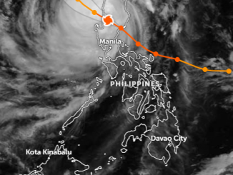
Published November 9, 2025 Aurora province is in the eye of a storm, literally and figuratively, as Super Typhoon Uwan (international name Fung-Wong) made landfall late Sunday night. With maximum sustained winds of 185 km/h […]
Image: Study: Greenland’s Melting Ice Unlikely To Trigger Atlantic Current’s Collapse Related: 30-Plus Signs That The Climate Scam Is Collapsing. The green swindle is dying, and they know it. Here, we detail its implosion Junk […]