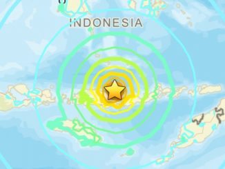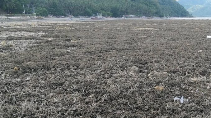
Coastal sea bed which was lifted following the 7.8 magnitude earthquake in Mindanao.
Published June 19, 2026
GLAN, Sarangani Province — June 2026
Residents along portions of the Sarangani coastline were stunned to discover what appeared to be a “dried-up sea” days after a powerful magnitude 7.8 earthquake struck offshore Mindanao on June 8.
Large stretches of previously submerged seabed, coral reefs, and marine habitats emerged above the waterline, creating an unusual landscape that quickly drew attention on social media. Photos and videos showing an apparently retreating shoreline led many to speculate that the sea had mysteriously disappeared.
However, scientists say the phenomenon is not a disappearing sea but rather a rare geological event known as coastal uplift.
Land Rose, Not the Sea
According to earthquake experts, the massive offshore quake caused sections of the Earth’s crust to move vertically. As a result, parts of the coastline in Sarangani and neighboring areas were lifted upward, exposing areas that had previously been underwater.
In some locations, the shoreline reportedly shifted hundreds of meters seaward, revealing coral formations, seagrass beds, and rocky seabed that had long remained submerged.
“This is a significant geological change caused by tectonic movement,” experts explained. “The sea level did not fall; instead, the land itself rose.”
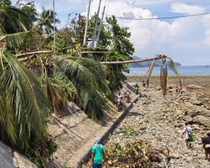
Damage on the coastline in Sarangani province, Philippines, on Thursday. Photograph: Xinhua/Shutterstock
Environmental Concerns
Marine biologists and environmental agencies have expressed concern over the sudden exposure of coral reefs and coastal ecosystems.
Corals that evolved underwater may suffer stress or die after prolonged exposure to air and sunlight. Seagrass meadows and other marine organisms could also be affected if the uplift remains permanent.
Environmental authorities are conducting assessments to determine the extent of ecological damage and identify measures needed to protect affected habitats.
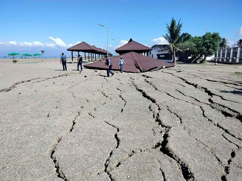
Several structures at a beach resort in Barangay Ladol in Alabel, Sarangani were damaged following a magnitude 7.8 earthquake and landslide on June 8, 2026.
Impact on Coastal Communities
The coastal transformation has altered fishing grounds and navigation routes used by local communities.
Fishermen have reported changes in water depth near the shore, while local officials are assessing whether ports, fish landing sites, and coastal infrastructure may require modifications.
Experts note that similar geological changes have been observed in other parts of the world following major earthquakes, particularly in regions located near active tectonic plate boundaries.
Reminder of the Region’s Seismic Activity
The earthquake occurred near the Cotabato Trench, one of the Philippines’ major earthquake-generating zones. The event generated tsunami warnings and caused damage across several areas in Mindanao.
Geologists emphasize that the exposed seabed serves as visible evidence of the immense forces released during large earthquakes.
Key Facts
- Magnitude 7.8 offshore earthquake struck near Sarangani on June 8, 2026.
- Portions of the coastline experienced coastal uplift.
- Previously submerged coral reefs and seabed became exposed.
Shorelines in some areas reportedly extended by hundreds of meters. - Scientists say the phenomenon is caused by tectonic movement, not a disappearance of seawater.
- Environmental agencies are studying the effects on marine ecosystems and local fisheries.
As investigations continue, the transformed coastline stands as one of the most dramatic reminders of the power of Earth’s shifting tectonic plates and the lasting impact major earthquakes can have on both landscapes and communities.
 Public / Political Reactions:
🏛️🇵🇭 Philippine Government (National Agencies + Local Officials)
Government agencies immediately launched investigations into the dramatic coastal changes observed in Sarangani following the magnitude 7.8 earthquake.
- PHIVOLCS confirmed that the exposed seabed was caused by earthquake-induced coastal uplift rather than the sea “drying up.”
- The Department of Environment and Natural Resources (DENR) initiated environmental assessments to evaluate impacts on coral reefs, seagrass beds, and marine ecosystems.
- Local government units coordinated relief operations, damage assessments, and public information campaigns to address community concerns.
➡️ Key message from the Philippine Government: Scientific evidence shows that the phenomenon resulted from tectonic uplift, and authorities are working to assess environmental and community impacts.
🏛️🌊 Scientists and Environmental Experts
Geologists and marine scientists described the event as one of the most visible examples of earthquake-related land uplift in recent Philippine history.
- Experts explained that the earthquake raised portions of the coastline, exposing areas that had previously been underwater.
- Marine biologists warned that prolonged exposure could damage coral reefs and other marine habitats.
- Researchers continue to monitor whether the geological changes will be permanent and how they may affect local fisheries.
➡️ Key message from Scientists: The coastline changed because the land rose, not because seawater disappeared.
🏛️🎣 Local Communities and Fisherfolk
Residents expressed a mixture of amazement, concern, and uncertainty after witnessing the sudden transformation of the shoreline.
- Many residents initially feared the receding water was linked to a potential tsunami or another natural disaster.
- Fisherfolk reported concerns about altered fishing grounds, navigation routes, and marine resources.
- Community members gathered to observe the exposed seabed, with photos and videos quickly spreading across social media.
➡️ Key message from Local Communities: While the event is remarkable, residents are concerned about its long-term effects on livelihoods and coastal resources.
🏛️📱 Public and Social Media Reaction
Images of the exposed seabed quickly went viral across the Philippines, generating widespread discussion online.
- Social media users referred to the phenomenon as a “dried-up sea” or “vanishing ocean.”
- Scientists and government agencies worked to counter misinformation by explaining the concept of coastal uplift.
- The event renewed public interest in earthquake science, disaster preparedness, and environmental conservation.
➡️ Key message from the Public: The phenomenon sparked both fascination and concern, highlighting the need for accurate scientific information during natural disasters.
 Resulting Effects
The powerful magnitude 7.8 earthquake that struck offshore Sarangani has produced significant geological, environmental, economic, and social impacts across affected coastal communities. While scientists continue to study the long-term consequences, the event has already transformed portions of the coastline and altered local marine ecosystems.
🌍 1. Coastline undergoes dramatic geological transformation
The most visible effect has been the sudden uplift of coastal land, exposing areas that were previously underwater.
🌊 Large sections of seabed, coral reefs, and coastal flats emerged above sea level.
📏 In some areas, the shoreline reportedly extended hundreds of meters seaward.
🪨 The event permanently altered parts of the coastal landscape, creating new land formations.
➡️ Result: Portions of the Sarangani coastline have been physically reshaped by tectonic movement.
🐠 2. Marine ecosystems face environmental stress
The exposed seabed has raised concerns among scientists and environmental agencies.
🪸 Coral reefs that were once submerged are now exposed to sunlight and air.
🌱 Seagrass beds and other marine habitats may experience long-term damage.
🔬 Environmental assessments are underway to determine the full ecological impact.
➡️ Result: Sensitive marine ecosystems may suffer habitat loss and reduced biodiversity.
🎣 3. Fishing communities experience livelihood disruptions
Changes to the coastline have affected traditional fishing areas and coastal activities.
🚤 Fishermen reported altered water depths and navigation routes.
🐟 Marine species may migrate as habitats change.
🏘️ Coastal communities face uncertainty regarding future fishing productivity.
➡️ Result: Local livelihoods dependent on marine resources may experience economic challenges.
📱 4. Public awareness and scientific interest increase
The unusual sight of a “dried-up sea” generated nationwide attention.
📸 Photos and videos of the exposed seabed quickly spread across social media.
🧑🔬 Scientists used the event to explain coastal uplift and earthquake-related geological processes.
📚 Public interest in disaster preparedness and earth science increased significantly.
➡️ Result: The event became a major educational example of how earthquakes can permanently alter landscapes.
⚠️ 5. Disaster preparedness efforts receive renewed attention
The earthquake served as a reminder of the Philippines’ vulnerability to major seismic events.
🚨 Authorities reviewed emergency response and tsunami preparedness measures.
🏛️ Local governments conducted damage assessments and community briefings.
🌋 Experts emphasized the importance of public awareness in earthquake-prone regions.
➡️ Result: Communities and government agencies are strengthening disaster risk reduction and preparedness initiatives.
🔍 6. Ongoing scientific monitoring continues
Researchers are closely observing the affected coastline to understand the long-term effects.
📡 Geological surveys are measuring the extent of land uplift.
🌊 Scientists are monitoring shoreline stability and environmental recovery.
📊 Data collected from the event may improve future earthquake and tsunami hazard assessments.
➡️ Result: The Sarangani earthquake is providing valuable scientific insights into tectonic activity and coastal change in the Philippines.
 Future Outlook
The coming weeks and months will be critical in determining the long-term impact of the Sarangani earthquake and the resulting coastal uplift. While the immediate geological changes are already visible, scientists, environmental agencies, and local communities continue to assess how the transformed coastline will affect ecosystems, livelihoods, and disaster preparedness efforts.
🌍 1. Scientific monitoring will continue
Researchers are expected to conduct detailed studies of the uplifted coastline and surrounding marine environment.
📡 Geological surveys will measure the extent and permanence of the land uplift.
🔬 Scientists will monitor changes in coastal stability, erosion patterns, and seismic activity.
📊 Data gathered from the event may improve future earthquake and tsunami hazard assessments.
➡️ Outlook: Continued monitoring will help experts better understand the long-term effects of major tectonic events.
🐠 2. Marine ecosystems will undergo adaptation and recovery
Environmental agencies will closely observe how exposed habitats respond to the sudden change.
🪸 Some coral reefs and marine organisms may not survive prolonged exposure above sea level.
🌱 Seagrass beds and coastal habitats could gradually adapt or be replaced by new ecosystems.
🔍 Conservation groups may recommend protective measures for vulnerable marine areas.
➡️ Outlook: Ecological recovery is possible, but some environmental changes may be permanent.
🎣 3. Coastal communities may need to adapt
Local residents and fishing communities are likely to face adjustments as the coastline continues to evolve.
🚤 Fishermen may modify navigation routes and fishing practices.
🏘️ Communities could adapt infrastructure to match new shoreline conditions.
💼 Local governments may introduce support programs for affected livelihoods.
➡️ Outlook: Economic and community adaptation will be important as residents adjust to the altered coastal environment.
⚠️ 4. Disaster preparedness will receive greater attention
The earthquake has reinforced the importance of readiness in one of the world’s most seismically active countries.
🚨 Authorities are expected to strengthen earthquake and tsunami awareness campaigns.
🏫 Schools and communities may increase participation in disaster preparedness drills.
📢 Government agencies will likely improve public education on geological hazards and emergency response.
➡️ Outlook: Greater public awareness could improve resilience during future natural disasters.
🌊 5. The coastline may remain permanently changed
Current evidence suggests that much of the uplifted land could remain above sea level for years or even decades.
📏 Newly exposed coastal areas may become a permanent part of the landscape.
🗺️ Future maps and coastal surveys may need to reflect the changed shoreline.
🏞️ The region could become an important site for geological and environmental research.
➡️ Outlook: The Sarangani coastline may serve as a lasting reminder of the powerful forces that shape the Philippine archipelago.
🇵🇭 6. Increased focus on earthquake science and risk reduction
The event has highlighted the importance of scientific research and public understanding of tectonic hazards.
🧑🔬 Researchers will continue studying the earthquake’s effects on land and marine environments.
📚 Public interest in geology, earthquakes, and coastal processes is expected to grow.
🤝 Collaboration among scientists, government agencies, and local communities will remain essential.
➡️ Outlook: The lessons learned from the Sarangani earthquake could contribute to stronger disaster risk reduction efforts across the Philippines.
 Bottom Line
The Sarangani “dried-up sea” was not a case of disappearing water, but rather a dramatic example of earthquake-induced coastal uplift caused by the powerful magnitude 7.8 Mindanao earthquake.
The event permanently altered portions of the coastline, exposed previously submerged marine habitats, and highlighted the immense geological forces operating beneath the Philippines.
🌍 Geologically, the earthquake reshaped parts of the coastline and created visible evidence of tectonic movement.
🐠 Environmentally, exposed coral reefs, seagrass beds, and marine ecosystems now face uncertain long-term impacts.
🎣 Economically, fishing communities and coastal residents may need to adapt to changing shorelines and marine conditions.
📚 Scientifically, the event provides researchers with a rare opportunity to study how major earthquakes can transform coastal landscapes.
⚠️ From a disaster preparedness perspective, the earthquake serves as a reminder of the Philippines’ vulnerability to seismic hazards and the importance of public awareness and emergency readiness.
➡️ Bottom Line: What appeared to be a “dried-up sea” is actually one of the most striking geological consequences of the 2026 Sarangani earthquake. The event has reshaped the coastline, raised important environmental questions, and demonstrated how a single earthquake can permanently change both the landscape and the lives of the communities that depend on it.
SOURCES: GMA NEWS ONLINE – Mindanao earthquake triggers coastal uplift in Sarangani, Davao Occidental; PHIVOLCS checking other areas
PHILSTAR – DENR to probe coastal uplift in Sarangani after Mindanao quake
PHILSTAR – Coastal uplifts observed in Sarangani post-quake