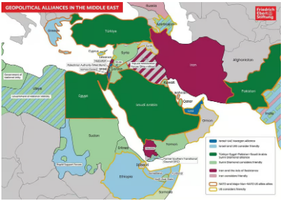
Israel and the UAE were shown as part of a “Hexagon Alliance”. The map showed Greece, Ethiopia and parts of India aligned with them. But it also showed a swath of southwestern Sudan as friendly to the UAE and Israel.
Reported by:

Cherry Meigh Timbol
News Content Editor
Published October 21, 2026
JERUSALEM — Israeli Prime Minister Benjamin Netanyahu has drawn international attention after displaying a map of regional alliances during a security briefing, prompting debate over how Israel views its strategic partners and rivals across the Middle East and parts of Africa.
The map, presented on October 18 alongside an updated Israeli national security doctrine, divided countries, territories and non-state actors into competing regional groupings. Its classifications included an Israel–United Arab Emirates alignment described as the “Hexagon Alliance,” a separate grouping labelled the “Sunni Diamond Alliance,” and Iran and its regional partners under the “Axis of Resistance.”
The graphic attracted attention because it portrayed certain territories controlled by armed or separatist groups as friendly to Israel and the UAE. Analysts said the presentation could intensify existing concerns about regional rivalries and the potential consequences of cooperation with non-state actors.
Map Identifies Unexpected Regional Alignments
The map showed Israel and the UAE aligned with several regional partners, including Greece and Ethiopia, while identifying areas associated with Libya’s eastern-based forces and Sudan’s Rapid Support Forces (RSF) as friendly to the grouping.
The RSF is a paramilitary organization fighting Sudan’s national army in a devastating civil war. The group has faced extensive allegations of atrocities, including accusations of genocide in Darfur. The UAE has been accused by Sudanese authorities and other observers of supporting the RSF, allegations Abu Dhabi has denied.
The map’s depiction of areas under RSF control as friendly to Israel and the UAE could therefore complicate perceptions of the two countries’ regional relationships.
In Libya, the graphic also identified territory controlled by forces led by Khalifa Haftar as aligned with the grouping. Yemen’s southern separatist movement and Somaliland were also depicted as friendly to Israel and the UAE.
These classifications do not necessarily establish formal alliances or prove that the groups have entered binding agreements with Israel. Rather, the map illustrates a proposed or perceived pattern of regional alignments.
Egypt, Turkey and Saudi Arabia Shown in a Separate Bloc
Another notable feature was the map’s depiction of Egypt, Turkey, Saudi Arabia and Pakistan within a grouping labelled the “Sunni Diamond Alliance.”
The presentation placed Jordan in a friendly relationship with that grouping rather than identifying it as part of the Israel–UAE alignment. This attracted attention because Jordan and Egypt both maintain formal peace agreements with Israel.
The map also illustrated Iran and its regional partners as a separate bloc, reflecting Israel’s longstanding concerns about Iranian influence and the activities of groups including Hezbollah and Yemen’s Houthi movement.
The graphic’s labels describe a geopolitical framework, not necessarily a set of formally established alliances. The countries shown may maintain different diplomatic, security and economic relationships that do not fit neatly into the categories presented.
A Map Originally Published by a German Foundation
The map was not originally produced by Netanyahu’s office. According to Al Jazeera, it was published in May 2026 by Germany’s Friedrich-Ebert-Stiftung, a political foundation, and was subsequently used in Netanyahu’s security presentation.
Its appearance during the briefing nevertheless attracted scrutiny because of the political context in which it was presented.
Netanyahu unveiled an updated national security doctrine that emphasized preventive military action, stronger domestic defenses, the expansion of buffer zones and the development of regional partnerships.
According to his office, the doctrine reflects lessons drawn from the October 7, 2023, Hamas-led attack on Israel and the conflicts that followed.
The document also emphasized preventing perceived threats before they develop into direct attacks against Israel. Critics have questioned whether such an approach could deepen regional instability, particularly if it involves prolonged military operations or control of territory beyond Israel’s internationally recognized borders.
Political and Diplomatic Implications
The timing of the presentation has also attracted attention because Israel’s parliamentary elections are scheduled for October 27, 2026. Netanyahu has faced domestic criticism over the government’s handling of security issues and the consequences of the conflicts involving Israel.
Opposition figures have criticized the new doctrine, arguing that its broad declarations lack sufficient detail. Analysts have also questioned whether the regional groupings shown on the map represent durable partnerships or an aspirational vision of Israel’s strategic position.
The map’s portrayal of non-state actors as friendly partners could create diplomatic complications for countries and groups whose public standing is already contested. It may also provide material for critics who argue that Israel’s regional strategy prioritizes security partnerships over the political stability of neighboring states.
However, the graphic alone does not establish that Israel has made new military commitments to the groups depicted or that all the relationships shown are operational alliances.
What the Map Reveals—and What Remains Unclear
Netanyahu’s presentation provides a glimpse into how Israel’s leadership frames regional security: through competing blocs, the containment of Iranian influence and the pursuit of partnerships beyond its immediate neighbors.
The map has generated questions about Israel’s relationship with the UAE, its view of regional separatist movements and the potential consequences of its security doctrine for fragile states.
Yet several important distinctions remain. A group being classified as friendly does not necessarily mean it has a formal alliance with Israel, and a map of regional relationships does not by itself prove that a coordinated strategy to divide neighboring countries exists.
The significance of the presentation will depend on whether the relationships it depicts translate into concrete diplomatic agreements, security cooperation or policy decisions.
For now, the map has placed Israel’s broader regional vision under renewed scrutiny, highlighting the complex and often competing interests shaping security across the Middle East and parts of Africa.